Dive visibility
Will the water be clear enough to dive?
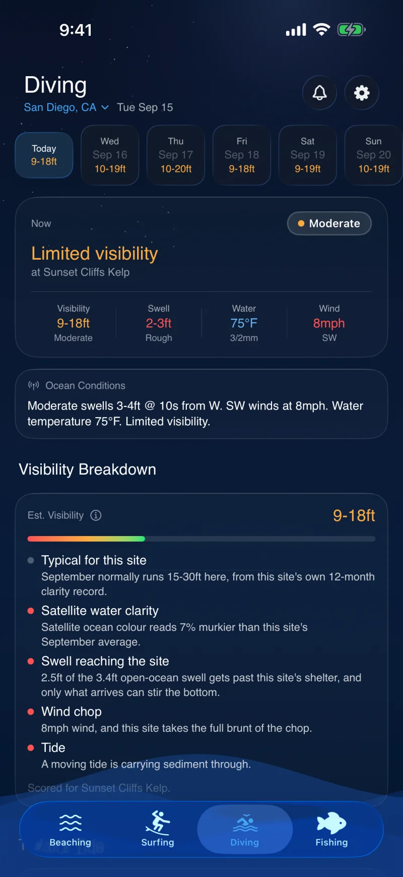
Visibility does not follow the regional forecast. A cove in the lee can stay clear through the swell that closes the coast, and a reef can go green from a river three miles away. Beachable scores 65 dive sites on their own terms and tells you which factor drove the answer.


How it works
A clarity model per site
Each site carries a twelve-month baseline visibility curve written for where it actually is, a ceiling it never beats, the arc of swell that reaches it, how much a river or storm drain affects it and whether current runs through it.
Local seasons, not a global curve
Tropical reefs follow the wet and dry seasons. Temperate coasts follow plankton rather than temperature. Southern hemisphere sites run on southern hemisphere time. The baseline is written per site, so no single seasonal rule is imposed anywhere.
Shelter is taken seriously
A swell that cannot reach the site does not count against it. The model admits only the energy that actually arrives, which is why protected sites stop reporting poor visibility every time the open ocean gets up.
Satellites, read as a change rather than a number
Satellite water clarity is unreliable as an absolute over shallow bright reef, where the bottom inflates the reading. So the reading is compared against that same patch of water's own monthly average, and the difference nudges the forecast. It catches the algal bloom and the river plume that no swell model shows.
It shows its working
Every factor the model actually evaluated is listed with the reading that drove it, so a poor verdict tells you whether it is the swell, the rain, the season or the wind. A factor the model does not use at that site is left out rather than shown as a zero.
The data
What it reads
Four live feeds plus the researched profile. Satellite data comes from NOAA CoastWatch, which blends instruments flown by NOAA, NASA and ESA.
Satellite water clarity
NOAA CoastWatch's gap-filled light attenuation product, from VIIRS and Sentinel-3 OLCI, compared against each site's own monthly baseline.
Swell and sea state
Buoy and model wave data, admitted through the site's exposure window rather than applied as an open ocean number.
Recent rainfall
Rain over the last 24 hours, which is what drives runoff and the brown water that follows it.
Recent sea state history
The last 48 hours of wave height, because water that was stirred up yesterday has not settled today.
Tide and current
Tide stage, weighted harder at sites where current is the thing that governs clarity.
Site profiles
Twelve-month clarity curve, visibility ceiling, swell exposure arc, runoff sensitivity and bloom months, researched per site.
Questions
Common questions
The answers below are also what the structured data on this page reports, so a search result cannot say something the page does not.
Where does the visibility number come from?
It is a forecast, not an observation. The site's own seasonal baseline is adjusted by the swell that actually reaches it, the last 48 hours of sea state, wind chop, recent rain, tide, and a satellite water clarity reading compared against that site's normal. The result is reported as a range rather than a single figure.
Why does a sheltered site read better than the regional forecast?
Because it usually is better. The model only counts swell arriving from directions that physically reach the site, so a cove behind a headland is not penalised for a swell breaking on the exposed coast a mile away.
Which sites are covered?
65 dive sites carry a researched profile, across 25 coastal regions worldwide. You can add any site that is missing; added sites fall back to a general estimate rather than a profile.
Can I be told when it clears up?
Yes, on Pro. Set a minimum visibility for a site and you get a notification when the forecast for that site clears it, quoted in the same units the app shows you.
The rest of the app
One app, four activities
Every activity is scored through its own physics rather than one shared number, and they all read the same live ocean data.
Beach tides
The hours a specific beach is walkable, from its own tide threshold rather than the tide table.
Surf forecast
Swell refracted onto the spot you are actually looking at, as a breaking face height.
Fishing forecast
Inshore and offshore judged on different physics, with the species actually in season.
Check the coast before you go.
Free on iOS and Android. Upgrade to Pro whenever you want the extended forecast and alerts.