Beach tides
When is the beach actually walkable?
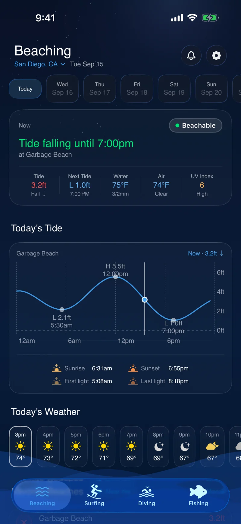
A tide table tells you the water height. It does not tell you whether there is any dry sand at the beach you are driving to. Beachable stores a tide threshold for each beach and turns the forecast into the hours that beach is walkable, trimmed to daylight.


How it works
A threshold per beach, not one rule for the coast
Two beaches an hour apart can need tides two feet apart before they are worth the drive. A wide flat beach might only disappear on a king tide. A pocket beach under a cliff might only exist below mid tide.
Every beach carries its own number
Each beach stores the tide height, in feet above chart datum, below which it has usable sand. Those were calibrated against NOAA tide station datums in the US and published tide tables elsewhere, then adjusted per beach for whether it is backed by a cliff, a seawall or dunes. You can edit any of them if you know your local beach better than we do.
A window, not an instant
The app solves the tide curve for the periods that sit under that beach's threshold, clips them to the hours between sunrise and sunset, and drops anything shorter than ninety minutes. What you get is a span you could plan around rather than a single number to interpret.
It says when it closes
A beach that is walkable now but has a rising tide within a foot of its threshold reads as closing soon, not as good. That distinction is the one that matters when you are deciding whether to go now or tomorrow.
Ten days out, and on your home screen
The window list runs ten days ahead, so you can pick the good Saturday rather than find out on the day. A notification at 5am tells you a window is coming, and an iOS home screen widget keeps a live countdown for up to six beaches without opening anything.
The data
What it reads
Tide is the one thing in this app that is genuinely predictable, so the beaching verdict is computed on your device from the tide curve. That is also why it keeps working when your signal does not.
Tide harmonics
WorldTides for the predicted curve, with NOAA CO-OPS as the fallback where a station covers the coast.
Sun times
Sunrise, sunset and the first and last light either side of them, so a window is never reported in the dark.
Verified beach pins
Every beach coordinate is checked against OpenStreetMap's mapped sand and moved to the nearest point on it, so the tide and weather are read where the beach is rather than at the town centre.
Weather
Hourly air temperature, conditions and UV alongside the window, because a walkable beach in driving rain is still a no.
Water temperature
Sea surface temperature from buoys where they exist, and a wetsuit thickness suggestion on Pro.
Wave height
Sea state from the same buoy and model feeds the surf forecast uses, factored into which upcoming days rank best.
Questions
Common questions
The answers below are also what the structured data on this page reports, so a search result cannot say something the page does not.
Is this just a low tide alert?
No. Low tide is a time, not a verdict. Whether a beach is walkable depends on how high the sand sits, which differs from beach to beach, so the same low tide leaves one beach wide open and another still underwater. Beachable compares the forecast tide against that specific beach's threshold and reports the hours it clears.
Which beaches are covered?
Beaches are seeded for your area from a catalog covering 25 coastal regions worldwide, including both US coasts, Hawaii, Ireland, Australia, Bali, Mexico, Costa Rica and Fiji. You can add any beach that is missing and set its threshold yourself.
Does it work without a signal?
The beaching verdict does. Tide is predicted rather than observed, so once the curve has been downloaded the app recomputes the windows on your device. That is why the home screen widget stays right when the app is closed.
What does it cost?
Today's conditions, the go or no-go verdict and every beach are free, with no account needed. Pro is 24.99 US dollars a year and adds the ten-day forecast, beach window notifications, the home screen widget and the detailed breakdown.
The rest of the app
One app, four activities
Every activity is scored through its own physics rather than one shared number, and they all read the same live ocean data.
Surf forecast
Swell refracted onto the spot you are actually looking at, as a breaking face height rather than an offshore number.
Dive visibility
Visibility scored from each site's own clarity curve, its shelter from swell and satellite water colour.
Fishing forecast
Inshore and offshore judged on different physics, with the species actually in season.
Check the coast before you go.
Free on iOS and Android. Upgrade to Pro whenever you want the extended forecast and alerts.